Smart Agriculture & IoT

Agricultural Drones & Crop Analysis

Aerial surveys cover an entire farm in a single flight, and AI-driven image processing turns every mission into clear maps of crop emergence, vigour, stress, disease and expected yield.

Agricultural Drones & Crop Analysis

Seeing every field from above

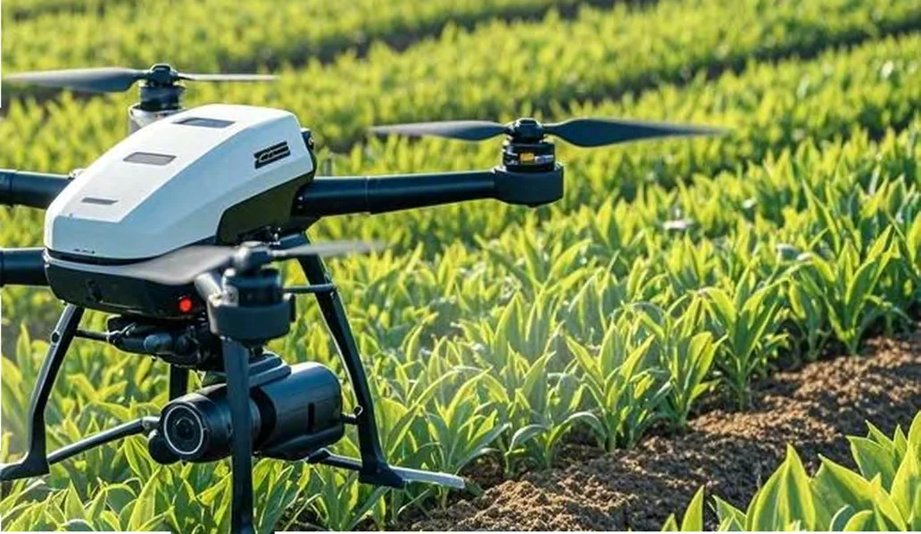
From sowing to harvest, drones fitted with visible-light, hyperspectral, multispectral, thermal infrared or LiDAR sensors photograph fields at regular intervals, and an image processing system built on large AI models interprets each data set. The results feed practical decisions: emergence maps show where replanting is needed, growth maps drive variable-rate fertilization, lodging maps quantify storm damage, spike counts forecast yield, and disease monitoring grades how severe an outbreak is. A single platform plans flight routes, runs missions in real time and displays the results. For farms, agricultural companies, cooperatives, insurers, research stations and government agencies in Saudi Arabia, drone analysis is a fast and objective way to manage large and remote areas. EnmaTech supplies the systems, trains operators and supports projects locally.

Drone Systems & Analysis

Agricultural UAV Patrol & Analysis System

Agricultural UAV Patrol & Analysis System

A complete patrol kit that pairs an industrial drone and a visible-light or hyperspectral camera with image processing and large-model analysis, following the crop through every growth stage.

  • CamerasVisible light / hyperspectral
  • PlatformImage processing + management platform
  • CropsRice, wheat, maize and more
  • OutputsEmergence, growth, lodging, yield, disease
Features & full specifications

Key features

  • Kit: industry-grade drone, visible-light or hyperspectral camera, image processing system and smart management platform
  • Seedling emergence analysis to guide replanting
  • Crop growth analysis to guide variable-rate fertilization
  • Lodging analysis to assess disaster losses
  • Spike (ear) counting and yield estimation
  • Pest and disease occurrence monitoring
  • Growth stage, malignant weed and male-removal (detasseling) detection

Available configurations

  • Visible-light patrol system
  • Hyperspectral patrol system

Technical specifications

CamerasVisible light / hyperspectral
PlatformImage processing + management platform
CropsRice, wheat, maize and more
OutputsEmergence, growth, lodging, yield, disease
Request a quote
Multi-Sensor Survey Drone

Multi-Sensor Survey Drone

A survey drone carrying LiDAR, visible-light, multispectral and thermal infrared sensors to collect detailed spatial and spectral data across the field.

  • SensorsLiDAR, visible, multispectral, thermal IR
  • DataSpatial and spectral maps
  • UseLarge fields and farms
Features & full specifications

Key features

  • LiDAR for terrain and canopy structure
  • Visible-light imagery for counting and inspection
  • Multispectral imagery for vigour and NDVI maps
  • Thermal infrared imagery for water stress detection

Technical specifications

SensorsLiDAR, visible, multispectral, thermal IR
DataSpatial and spectral maps
UseLarge fields and farms
Request a quote
Drone Remote-Sensing Analysis Platform

Drone Remote-Sensing Analysis Platform

One control platform for planning flight routes, operating drones in real time and viewing the images, data layers and analysis results they produce.

  • FunctionsRoute planning, operation, visualisation
  • LayersVisible, multispectral, thermal, LiDAR
  • OutputMaps and reports
Features & full specifications

Key features

  • Flight route planning over each field
  • Real-time drone operation and status
  • Visualisation of captured images and data layers
  • Analysis results and reports per field and season

Technical specifications

FunctionsRoute planning, operation, visualisation
LayersVisible, multispectral, thermal, LiDAR
OutputMaps and reports
Request a quote
Crop Analysis Reports

Crop Analysis Reports

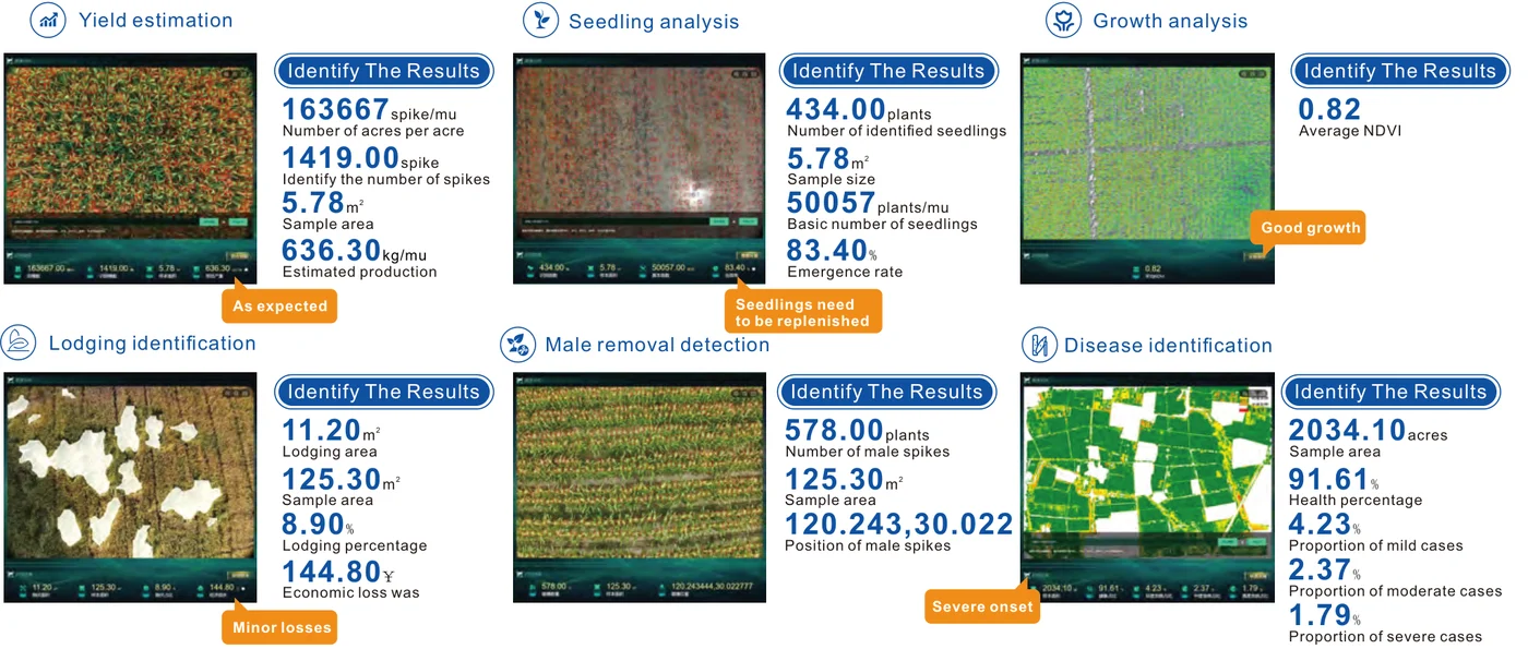
Sample outputs the image processing system returns after each flight, ranging from spike counts and emergence rates to disease severity proportions.

  • Emergence rate (sample)83.40%
  • Average NDVI (sample)0.82
  • Lodging percentage (sample)8.90%
  • Health percentage (sample)91.61%
Features & full specifications

Key features

  • Yield estimation: spikes per area, identified spikes and estimated production
  • Seedling analysis: identified seedlings, plants per area and emergence rate, with replanting alerts
  • Growth analysis: average NDVI with growth rating
  • Lodging identification: lodging area, percentage and economic loss
  • Male removal detection: number and position of male spikes
  • Disease identification: health percentage and mild, moderate and severe case proportions

Technical specifications

Emergence rate (sample)83.40%
Average NDVI (sample)0.82
Lodging percentage (sample)8.90%
Health percentage (sample)91.61%
Request a quote
Drone Analysis Services

Drone Analysis Services

Eight standard analyses generated from multi-sensor flights, each supplied as a map layer with a written summary.

  • Analyses8 standard map products
  • DeliveryMap layers and summaries
Features & full specifications

Key features

  • Thermal infrared collection
  • Seedling analysis
  • Disease identification
  • Lodging identification
  • Yield estimation
  • Disease grade
  • Growth analysis
  • Severe water shortage detection

Technical specifications

Analyses8 standard map products
DeliveryMap layers and summaries
Request a quote
Drone AI Models

Drone AI Models

AI models that convert drone imagery into forecasts and treatment prescriptions tailored to each field.

  • ModelsYield, disease, growth, phenotype, terrain, water, fertilization
  • OutputVariable-rate prescriptions and forecasts
Features & full specifications

Key features

  • Yield prediction
  • Pest and disease analysis
  • Crop growth monitoring
  • Intelligent phenotype recognition
  • Terrain analysis
  • Field water requirement
  • Field fertilization prescription

Technical specifications

ModelsYield, disease, growth, phenotype, terrain, water, fertilization
OutputVariable-rate prescriptions and forecasts
Request a quote

Higher yield and better quality

Growth and NDVI maps highlight weak zones early in the season, so fertilizer and crop care can be adjusted field by field before losses build up.

Early warning and loss assessment

Maps of disease, lodging and water shortage expose problems quickly and record the affected area, supporting management decisions and insurance claims.

Lower pesticide and input use

Variable-rate prescriptions place fertilizer, water and crop protection products only where the analysis shows a need, saving both water and chemicals.

Harvest and market planning

Spike counts and pre-harvest yield estimates give early figures for logistics, storage and sales planning.

Frequently Asked Questions

Which crops can drone analysis cover?

The analysis models are well established for cereals such as wheat, rice and maize and can be applied to many other field crops. EnmaTech confirms which models are available for your crops while planning the project.

What does each flight deliver?

That depends on the sensor and model used. Typical outputs include seedling counts and emergence rate, average NDVI with a growth rating, lodging area and percentage, male-spike detection, the share of healthy plants with disease severity proportions, and spike counts with estimated production.

Do we need our own drone pilots?

Not necessarily. Flight routes are planned on the platform and missions are largely automated. EnmaTech can train your team in Saudi Arabia or include flight services in the project scope.

Bring aerial crop analysis to your farm

Share your crops and the area you manage, and EnmaTech will propose the right drone, sensor set and analysis package for your operation.